Mont Aigre
Estérel Côte d'Azur
Pedestrian sports, Hiking itinerary

Randonnée : Le Mont Aigre

This easy hike will take you to a superb viewpoint over the bay of Fréjus / Saint-Raphaël and the Rocher de Roquebrune. Our advice? Do it at sunset!

Description

> ACCÈS
Depuis Fréjus, suivre les Adrets de l’Estérel sur la DN7. Se garer au parking du Col du Testanier.

> POINT DE DÉPART
Coordonnées GPS : 43.501347, 6.794720
Parking du Col du Testanier

> ITINÉRAIRE

Depuis le parking, prendre la piste des Charbonniers qui part sur la droite en contrebas de la route qui mène au Mont-Vinaigre. À la première intersection, prendre à droite. Descendre au fond du vallon pour atteindre le niveau du ru. La piste commence alors à remonter pour atteindre une intersection. Prendre à gauche. Quelques mètres plus loin, arriver à une intersection en épingle. À cette intersection en épingle, prendre à droite. Continuer la montée pour rejoindre la Route d’italie. Continuer à droite pour atteindre la Maison Forestière
des Cantonniers.

Quitter ensuite le sentier principal pour rejoindre la piste de l’Aigre, juste à droite
de la citerne verte.

Environ 400 mètres plus loin, atteindre l’intersection du Pas d’Adam. Poursuivre à gauche, dépasser les rochers sur votre gauche pour atteindre un terre-plein.

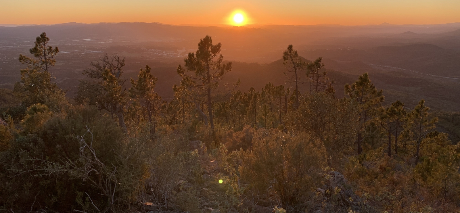
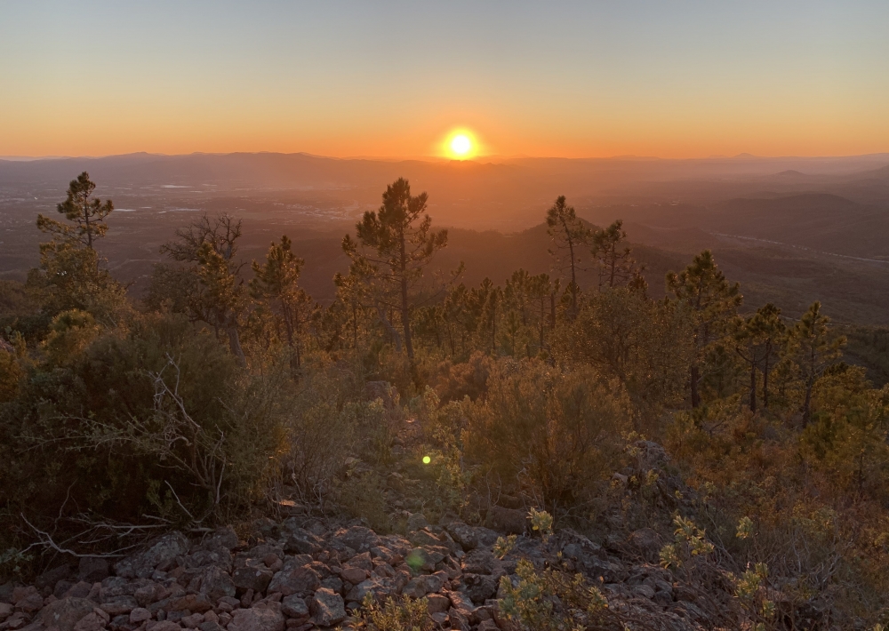
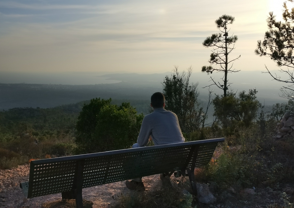
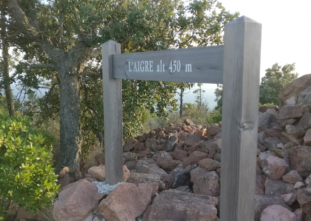
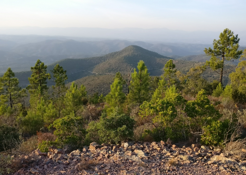
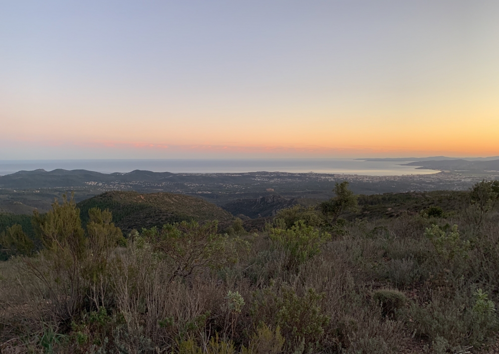
Continuer sur la piste principale, balisée en bleu. À l’intersection suivante, prendre à gauche puis quitter le sentier en empruntant celui de droite qui monte au sommet du Mont Aigre (450 mètres d’altitude). Un banc vous permet d’admirer la vue. Derrière, un kern ainsi qu’un panneau annonce le sommet. En continuant dans ce sens, rejoindre la crête qui offre un superbe panorama sur l’Estérel et la baie de Fréjus Saint-Raphaël.

Rejoindre le sentier qui descend en lacet jusqu’à la Route d’Italie. Prendre
à droite pour rejoindre la Maison Forestière du Malpey. Descendre la route sur 100m jusqu'au parking. Monter les marches à gauche du panneau touristique sur le massif de L'Esterel. Suivre le balisage du GR51 à gauche qui longe la route en contrebas pour rejoindre votre parking de départ.

Further information

  • flag-FRFrench
  • Type of customers : 
    Level bue - Medium
  • Equipments : 
    Car park
    Free car park
  • On-site activities : 
    Pedestrian sports
    Hiking itinerary
  • Environments : 
    Forest location
    Sea view
    Panoramic view
Estérel Côte d'Azur depending on your mood
Weather
Sea side
Today
-- °C Wind : -- km/h
Tomorrow
-- °C Wind : -- km/h
After tomorrow
-- °C Wind : -- km/h
Hinterland
Today
-- °C Wind : -- km/h
Tomorrow
-- °C Wind : -- km/h
After tomorrow
-- °C Wind : -- km/h
Water temperature
Fréjus -- °C
Saint-Raphaël -- °C
Les Issambres -- °C
+
-

Clic on areas to zoom in

Clear map
Dark map
Map zone 1
Map zone 2
Map zone 3
Map zone 4
Map zone 5
Map zone 7
Map zone 6
Map zone 8
pays de fayence - nord

Fayence area

The Pays de Fayence (Fayence district) has many great provencal villages. All of them have a particularity such as the view from Mons or the artistic streets of Tourrettes. Do no forget to stop in Seillans that has the label of "Most beautiful village in France"

Go back to map
pays de fayence - sud

Fayence area

North of the A8 motorway, you will find the Pays de Fayence. Saint-Cassien lake, a real oasis of freshness in the Var, awaits you! Take a break at the Lake House before visiting the villages of Bagnols-en-Forêt, St-Paul-en-Forêt or Tanneron.

Go back to map
roquebrune sur argens - la bouverie

Roquebrune-sur-Argens

The city of Roquebrune-sur-Argens is the most westerly of the destination. It includes three districts: La Bouverie, at the foot of Gorges du Blavet; The village, overlooked by its magnificent rock, and Les Issambres, with its nautical activities by the sea.

Go back to map
les adrets de l'esterel

Les Adrets de l'Estérel

Les Adrets de l'Estérel is a small town located at the extreme southeastern Var. Bordering the Maritimes Alpes, it is composed of large green forests. The town overlooks the bay of Cannes and has an exceptional view on the Lérins Islands and the Corniche de l'Estérel.

Go back to map
village de puget sur argens

Puget sur Argens

Puget sur Argens is a small village located in the middle of many wineries. Its commercial area, near the village, includes many shopping center. North of the village, the Bois du Defens give rise to several walks.

Go back to map
roquebrune-sur-argens - les issambres

Les Issambres

Welcome to Les Issambres, the district of Roquebrune-sur-Argens located on the coast. True paradise with its 8 km of beaches and creeks, this family seaside resort, already frequented at the time by the Romans, is located between the Gulf of Saint-Tropez and Fréjus-Saint Raphaël.

Go back to map
ville de frejus - saint-aygulf

Fréjus

Frejus, located halfway between Cannes and Saint-Tropez, is at the heart of the Côte d'Azur. Based on a sandstone buttress of the Esterel massif, the town dominates the valleys of Argens and Reyran. Frejus has the appearance of a small Provencal town whose new districts extend to the sea.

Go back to map
saint-raphael - massif de l'esterel

Saint-Raphaël

65km from Nice Côte d'Azur International Airport, Saint-Raphaël is located between Cannes and Saint-Tropez. This seaside resort on the Mediterranean coast is at the bottom of the great Esterel mountains. Saint Raphael, whose city center is by the sea, is divided into different neighborhoods that have all their characteristics and their personalities.

Go back to map
Fayence areaFayence areaRoquebrune-sur-ArgensLes Adrets de l'EstérelPuget sur ArgensLes IssambresFréjusSaint-Raphaël
Webcams
Subscribe to our newsletter