Carte du Chemin de Compostelle
Association Provence-Alpes-Côte d’Azur-Corse des Amis des Chemins de Saint-Jacques-de-Compostelle et de Rome
Pedestrian sports, Hiking itinerary

The Way of St. James - GR® 653A - E12

The GR®653A trail stretching from Menton to Arles is officially one of the long-distance hiking routes on the Way of St. James in France. These routes are included in the UNESCO World Heritage list, and this section is part of the European E12 "Mediterranean Arc" trail.

Description

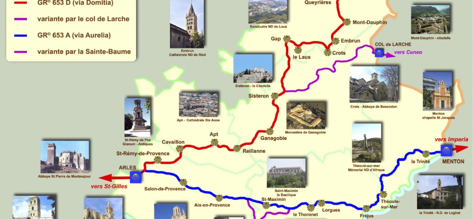
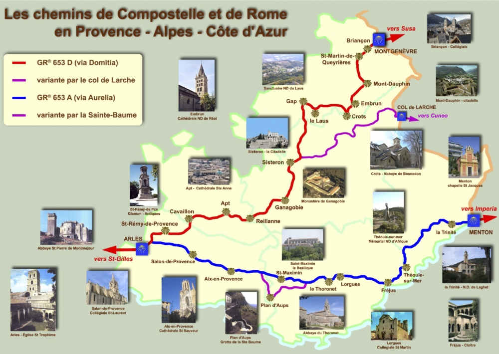
Il traverse d'est en ouest tout le département du Var sur une longueur de 138 kilomètres, en suivant le tracé de l’ancienne voie romaine, la Via Aurelia.

Il débute au Col Notre Dame, dans le massif de l’Estérel, passe par Saint Raphaël, Fréjus, Puget-sur-Argens, longe Roquebrune-sur-Argens, traverse Le Muy, les Arcs-sur-Argens, Lorgues, fait étape à l’Abbaye du Thoronet, passe à Carcès, longe Vins-sur-Caramy, traverse Le Val, Bras, Saint-Maximin, Ollières et enfin Pourrières pour se diriger vers Aix-en-Provence.
Une variante permet de se rendre à la grotte de sainte Marie-Madeleine dans le massif de la Sainte Baume ; elle débute au Val, traverse Brignoles, Tourves, Rougiers, Plan d’Aups Saint-Zacharie et rejoint le GR à Puyloubier.

Que vous soyez pèlerin ou simple randonneur sachez que si les étapes varoises du chemin de Saint-Jacques-de-Compostelle et de Rome ne sont pas encore très connues, elles n’en sont pas les moins belles ! En parcourant ce chemin vous irez en effet de surprise en surprise :
. Vous foulerez 2000 ans d’histoire,
. Vous découvrirez un patrimoine architectural exceptionnel (Fréjus, l’Abbaye du Thoronet ou encore Saint-Maximin, 3ème tombeau de la chrétienté),
. Vos vous émerveillerez devant de splendides paysages.

Further information

  • flag-FRFrench
  • On-site activities : 
    Pedestrian sports
    Hiking itinerary
Estérel Côte d'Azur depending on your mood
Weather
Sea side
Today
-- °C Wind : -- km/h
Tomorrow
-- °C Wind : -- km/h
After tomorrow
-- °C Wind : -- km/h
Hinterland
Today
-- °C Wind : -- km/h
Tomorrow
-- °C Wind : -- km/h
After tomorrow
-- °C Wind : -- km/h
Water temperature
Fréjus -- °C
Saint-Raphaël -- °C
Les Issambres -- °C
+
-

Clic on areas to zoom in

Clear map
Dark map
Map zone 1
Map zone 2
Map zone 3
Map zone 4
Map zone 5
Map zone 7
Map zone 6
Map zone 8
pays de fayence - nord

Fayence area

The Pays de Fayence (Fayence district) has many great provencal villages. All of them have a particularity such as the view from Mons or the artistic streets of Tourrettes. Do no forget to stop in Seillans that has the label of "Most beautiful village in France"

Go back to map
pays de fayence - sud

Fayence area

North of the A8 motorway, you will find the Pays de Fayence. Saint-Cassien lake, a real oasis of freshness in the Var, awaits you! Take a break at the Lake House before visiting the villages of Bagnols-en-Forêt, St-Paul-en-Forêt or Tanneron.

Go back to map
roquebrune sur argens - la bouverie

Roquebrune-sur-Argens

The city of Roquebrune-sur-Argens is the most westerly of the destination. It includes three districts: La Bouverie, at the foot of Gorges du Blavet; The village, overlooked by its magnificent rock, and Les Issambres, with its nautical activities by the sea.

Go back to map
les adrets de l'esterel

Les Adrets de l'Estérel

Les Adrets de l'Estérel is a small town located at the extreme southeastern Var. Bordering the Maritimes Alpes, it is composed of large green forests. The town overlooks the bay of Cannes and has an exceptional view on the Lérins Islands and the Corniche de l'Estérel.

Go back to map
village de puget sur argens

Puget sur Argens

Puget sur Argens is a small village located in the middle of many wineries. Its commercial area, near the village, includes many shopping center. North of the village, the Bois du Defens give rise to several walks.

Go back to map
roquebrune-sur-argens - les issambres

Les Issambres

Welcome to Les Issambres, the district of Roquebrune-sur-Argens located on the coast. True paradise with its 8 km of beaches and creeks, this family seaside resort, already frequented at the time by the Romans, is located between the Gulf of Saint-Tropez and Fréjus-Saint Raphaël.

Go back to map
ville de frejus - saint-aygulf

Fréjus

Frejus, located halfway between Cannes and Saint-Tropez, is at the heart of the Côte d'Azur. Based on a sandstone buttress of the Esterel massif, the town dominates the valleys of Argens and Reyran. Frejus has the appearance of a small Provencal town whose new districts extend to the sea.

Go back to map
saint-raphael - massif de l'esterel

Saint-Raphaël

65km from Nice Côte d'Azur International Airport, Saint-Raphaël is located between Cannes and Saint-Tropez. This seaside resort on the Mediterranean coast is at the bottom of the great Esterel mountains. Saint Raphael, whose city center is by the sea, is divided into different neighborhoods that have all their characteristics and their personalities.

Go back to map
Fayence areaFayence areaRoquebrune-sur-ArgensLes Adrets de l'EstérelPuget sur ArgensLes IssambresFréjusSaint-Raphaël
Webcams
Subscribe to our newsletter